Participate in Seattle’s first emergency prepardeness “hub-a-thon”


After a successful round of Hub Chats held March 24-25, it is clear neighborhood leaders want to connect with other groups organizing for disaster. The Seattle Emergency NeighborLink map will launch within the next week. For more details on the map and how to connect during the Hub-a-thon, see FAQs below: 

What’s going on? Two big things …
This month, the Seattle Emergency NeighborLink map makes its on-line debut. If you are part of the SNAP list*, you will automatically receive a link to this website.

Then, on April 17-18, Seattle Emergency Management will host the first-ever Seattle “Hub-a-thon!”

*sign up for the SNAP list at: http://www.seattle.gov/lists/eocsnap.htm 

What is a Hub-a-thon?
It’s a virtual meet-up of neighborhood coordinators who have organized their group for safety and disaster preparedness. Neighbors connect themselves via the new Seattle Emergency NeighborLink map.

What is the Seattle Emergency NeighborLink map?
An interactive Google map where you can connect with other neighborhood coordinators directly and see who else has organized around you.

Why Seattle Emergency NeighborLink?
If you’ve ever wondered who else has formed a neighborhood group around safety or disaster preparedness, there has never been a way to easily locate or contact others. But now with NeighborLink, there is! 

Why does this matter?
In any large-scale regional disaster, city resources will be overwhelmed, and people will have to rely on those around them to get through the first few days and weeks. Connecting with people now, and exchanging information ahead of time, will be an important way for neighbors to stay safe and help each other when the time comes.

Can anyone participate?
While anyone can view the map, group information should be posted by either your neighborhood coordinator, community agency, or someone you designate. Seattle Emergency NeighborLink will only show Seattle-based SNAP, Block Watch, Hub groups and CERT individuals. CERT members are asked to associate with their nearest Seattle-based Hub. 

How do I participate?
Go to: www.seattleemergencyhubs.org(website is currently being updated)
Look for the Seattle Emergency NeighborLink map on the home page. (Google Map won’t be live until early April.)

Click and fill in the form for SNAP, Block Watch, Hub or CERT.

Send in your information and watch for your group to show up on the map during the April 17-18 Hub-a-thon! 

What if I’m not part of SNAP, Block Watch, Hub or CERT? Can I still add myself to the map?
No, but if you want to start your own SNAP, Block Watch or Hub group, you’ll be able to link out to those websites for more information.

Once I see the map is live, do I have to wait to be part of the Hub-a-thon?
No! In fact, the more people who fill in the form early, the faster people can start connecting. The first day of the Hub-a-thon is just the beginning. The map will constantly be updated as people keep adding themselves to the map.

Our group doesn’t use computers. Can we still participate in the Hub-a-thon and become part of the Seattle Emergency NeighborLink map?
Yes! The Hub-a-thon is set for Fri, April 17 from 10 a.m. – 4 p.m. and Sat, April 18 from 10 a.m. – 2 p.m. Have a member of your group stop by the American Red Cross anytime during those times. We will take your information and enter it into the computer for you. It’s that easy.

Or, call 206-684-0517 during the Hub-a-thon and we will take your information over the phone. 

What happens after the Hub-a-thon?
Start connecting with other neighborhood coordinators via email! The NeighborLink map will be your ready resource to help you plan and organize with other groups around you. 

Anything else?
Stay tuned to the SNAP email list* for future announcements on SNAP and Hub training. Seattle Office of Emergency Management is committed to helping our community connect and plan together for disaster. *See link above or email: snap@seattle.gov

For more information, contact Debbie Goetz, Seattle Office of Emergency Management, email: debbie.goetz@seattle.gov or call 206-684-0517.

Please send questions or comments to mailto:eocsnap-request@talk2.seattle.gov | Privacy Policy

Seattle Office of Emergency Management | 105 5th Avenue South, Suite 300 | Seattle | WA | 98104

Two April workshops offered for Large Projects Fund applicants

A Large Project Fund grant helped build Ballard Corner’s Park

Neighborhood Matching Fund supports neighborhood-initiated projects

The Neighborhood Matching Fund, a program of Seattle Department of Neighborhoods, is hosting its last two workshops for those interested in applying to the Large Projects Fund this May. The Large Projects Fund provides matching funds of up to $100,000 to neighborhood groups for community-building projects. Attendance at one of these workshops is required to submit a Large Projects Fund application.

The mandatory workshop will provide an overview of the Neighborhood Matching Fund, the qualities of a strong application, and the review process. Neighborhood and community groups interested in applying are invited to attend. The final workshop dates and locations are as follows:

Wednesday, April 1, 6 – 8 p.m.
Garfield Community Center, 2323 E. Cherry St.

Thursday, April 9, 6 – 8.p.m.
El Centro de la Raza, 2524 16th Ave S

To attend a workshop, RSVP at surveymonkey.com/s/LPFWorkshop2015 or contact NMFund@seattle.gov or 206-733-9916. To request childcare or interpretation services, contact us at least 3 days prior to your preferred workshop.

The deadline for the Large Projects Fund is May 4 at 5:00 p.m. To learn more, visit seattle.gov/neighborhoods/nmf/largeproject.htm.

The Neighborhood Matching Fund (NMF) Program awards matching funds for projects initiated, planned, and implemented by community members. Its goal is to build stronger and healthier neighborhoods through community involvement and engagement. Every award is matched by a neighborhood’s contribution of volunteer labor, donated materials, in-kind professional services, or cash. 

Update on the East Ballard Green Streets

EastBallardGreenStreets

Come meet Cari and learn more about this project at Groundswell NW’s Annual Meeting and Civic Social on Tuesday March 24 6pm at the Nordic Heritage Museum.

Project Update:
Big changes are in the works for the planting strip area between the sidewalk and the street, along 11th Avenue NW between NW 58th and 56th streets. A design team comprised of local engineers and landscape architects, Antioch University Seattle students and faculty, Ballard High School students, Surfrider members and community volunteers from East Ballard are poised to construct a series of voluntary roadside rain gardens.

Polluted runoff starts as clean rainwater that then comes in contact with toxins in our built environment, such as vehicle exhaust particles that settle on the ground, oil leaks, pet waste, garbage and other chemicals that end up on our roads, parking lots, roofs or other hard surfaces and flows into the nearest catch basin, which collects runoff underneath the drains found on most street corners. Currently, rain water flows freely down the roadway surface and into the nearest storm drain, and often overwhelms the system and causes localized flooding.

East Ballard contributes approximately 2 million gallons of roadway runoff to Salmon Bay each year through catch basins that connect into one big pipe that empties into Salmon Bay near the Fred Meyer store at the 11th Avenue NW shoreline street end, with no treatment or filtration. Pollution from roadway runoff enters the food chain and affects the health of marine creatures and the people who eat fish or shellfish.

Imagine three Olympic sized swimming pools filled with roadway runoff draining into Salmon Bay every year!

What are roadside rain gardens?
Our roadside rain garden projects, also known as natural drainage or biofiltration, will be engineered to absorb and filter the roadway runoff through cuts in the curb that allow water to flow into planted swales that will drain quickly to prevent ponding.

The group has been working with Seattle Department of Transportation and Street Use to apply for a Voluntary Roadside Rain Garden Street Use permit, while also working with City staff to make the permit rules more accessible by community organizations. In the future, there may be grant programs or other opportunities for community organization or groups of neighbors to apply for a permit to transform their block, and this project will provide information, guidelines and lessons-learned.

Neighborhood history – the “11th Avenue Creek”
We learned from residents and our research at the Seattle Municipal Archives, that an historic creek used to run parallel to 11th Avenue NW, from above where Ballard High School football field is down to Salmon Bay next to where the Fred Meyer store is located today. Prior to 1860, this area was densely forested with several small creeks draining down into Salmon Bay, which had a large area of tidal mud flats and marshes ringing the edge of the bay. One of the creek’s early names was the Lushootseed name for Evergreen Huckleberry, a native plant with edible berries. Evergreen Huckleberry will be one of the featured plants in the 11th Avenue NW roadside rain garden planting plan.

In the early 1900s the creek was put into a pipe as the City of Ballard expanded and was developed. Even on dry days you can hear the creek flowing in the pipe under 11th Avenue NW (please be very careful if you stand in the roadway!) under the manholes that have “BSS” stamped on them.

What is East Ballard Greenstreets?
In an effort to improve urban water quality and neighborhood livability, The Russell Family Foundation awarded Antioch University Seattle with funding to site, design and build demonstration roadside rain gardens in the East Ballard neighborhood of Seattle. We welcome any residents from the area to get involved and help coordinate the design and construction process with the E. Ballard property owners.

For more information, please contact Cari Simson, Project Manager:
cari@urbansystemsdesign.com / 206-234-5102

Learn more about the project on their Facebook page: https://www.facebook.com/EastBallardGreenstreet

Help Prepare Ballard Corners Park for the Summer

photo courtesy of Friends of Ballard Corners Park

The Friends of Ballard Corners Park invite you to a work party!

Ballard Corners Park Work Party
March 28, 9AM-2PM
17th Ave NW and NW 63rd
rain or shine!

You will be preparing plants for Spring, weeding, spreading wood chip mulch, and cleaning up debris. The bulbs you added last Fall are getting ready to bloom – come enjoy the fruits of your past labor and help get the Park in shape for Summer fun! Some tools and refreshments will be provided. If you have your own gloves and tools please bring them.

Any questions, please contact Gabriella

You’re invited to Groundswell NW’s Annual Meeting & Civic Social March 24

GNWMarch24AnnualMtgPoster

You’re invited to this special event that will change the landscape of your community and grow the public green.

This year, Groundswell NW will be highlighting the findings from the Ballard Open Space Plan and looking to you to spark future parks, public art, gardens, green space connectors and habitat in Northwest Seattle.

Because you are a mover and shaker in this great community, your participation in this collaborative event is crucial.

Groundswell NW will also present “Local Heroes” awards, which recognize individuals and groups who have made outstanding contributions to parks and open space in Ballard.

Doors open at the Nordic Heritage Museum at 6PM for an open house where you can learn more about Groundswell NW’s partners and projects.
The Civic Social will begin at 6:30PM.

You bring your best ideas, Groundswell NW will bring the treats.

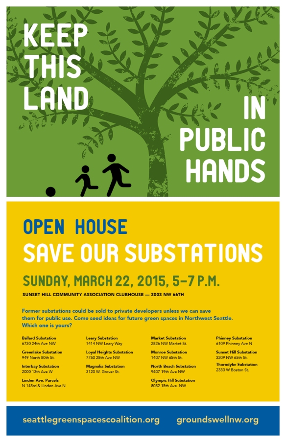
Save Our Substations Open House March 22

MonroeSubstation

If you’ve ever walked to the bus at 15th and 65th or to El Camion for a taco, you’ve probably walked by the vacant Monroe Substation at 1407 NW 65th and wondered what the heck is going on there. Well, the truth is, nothing, at least not yet. This vacant substation along with many more in our neighborhood and across Seattle are former Seattle City Light substations that are still owned by the City and could be up on the auction block to private developers in the near future. You are invited to join Seattle Green Spaces Coalition on March 22 at the Sunset Hill Community Club from 5-7PM to show your support to “keep these public lands in public hands” and share your ideas on how these spaces can used in your community.

03-08-15-seattlegreenspacecoalition

4 Ballard Neighborhood Park and Street Fund Project applications move to the next step

Seeking a safer crossing at 11th and Market

Seeking a safer crossing at 11th and Market

In a previous post we encouraged you to show up at the Ballard District Council meeting this week to show support for 3 East Ballard street improvement projects that were submitted. There were over 12 applications submitted for Ballard/Crown Hill. The Ballard District Council review committee narrowed the list down to 6 for the Ballard District Council to review and vote. Thank-you to the review committee for taking the time to visit each proposed site and making the tough decisions. Thank-you to our neighbors who, instead of just complaining about a problem in the community, took action by submitting very thoughtful applications.

In the end, 4 applications were selected by the Ballard District Council to go to SDOT for cost evaluation. Note that 2 of these projects are from East Ballard!

  • A crosswalk at NW 85th between 10th and 11th Ave NW
  • Converting existing right of way at 17th Ave NW and Dock St along the next Ballard Greenway
  • Improved crossing of 8th Ave NW south of Market St
  • Improved crossing at Market St and 11th Ave NW

SDOT will report back to the Ballard District Council and based on the amount of funds available, the Council will vote again on which projects to recommend for implementation. Thank-you to all who attended this weeks Council meeting to show support for your project. We’ll continue to keep you posted!


Join Whittier Heights Involved Neighbors for 15th Ave NW Street Clean up

Whittier Heights is just a bit north of East Ballard, but I know we all travel along 15th Ave NW at one time or another. So why not come out and help these ambitious neighbors help make 15th a bit nicer.
Whittier Heights Involved Neighbors (WHIN)
15th Ave NW Street Clean Up 
Saturday 3/14, 1PM-3PM
Meet at NW 85th and 15th Ave NW in front of Walgreens

Organizers will have trash bags and some gloves and trash grabbers but please bring your own gloves if you have them as supplies are limited. Wear reflective gear or bright colored clothing if possible.

For more info, contact: Gina Frank, gina.a.gibbs@gmail.com and if you live in the Whittier Heights, sign up to be a member of WHIN’s Facebook page

A sneak peek at designs for the 11th Ave NW Shoreline Street End Project

11thAve_BirdsEyeView

Bird’s eye view

If you attended the 11th Ave NW shoreline street end project open house in January, then you’ll remember an energy-filled evening at the Ballard Library. During this evening, talented and enthusiastic UW students from Professor Daniel Winterbottom’s Landscape Architecture Design/Build class presented their design ideas to transform the 11th Ave NW shoreline street end into an inviting public space.

After the open house, Professor Winterbottom’s students returned to the classroom with your feedback and collaborated with Seattle Dept of Transportation’s Jennifer Wieland and Shannon Glass to develop a “final” design for the 11th Ave NW Shoreline Street End and Viewing Deck that will now advance through City’s permitting process.

11thAve_shorelineView

Shoreline view

You’ll see that the “final” design blends aspects of many of the preliminary designs, including a maypole, a meandering pathway, a swing, and a deck with seating at the water’s edge. The design also includes a new fire access point for the adjacent property to the west and accounts for the turning radius needed by the business to the east. The design also incorporates bike parking, an ADA-accessible parking stall, and a wide variety of native plantings.

You can access the siteline drawings via DPD’s website by entering 3018782 in the Search by Number field. If you sort by Capture Date, you’ll find a posting from 2/19/15 called “Plan Set: Plan SetV3.” These are technical drawings rather than renderings.

The EBCA also has also been in touch with Professor Winterbottom’s class to receive site illustrations, a couple of which we’ve provided in this post, that will help you really visualize what this space will look like.

You are also invited to an event on March 13 to view the final designs and attend a panel discussion on design education, its form, experimentation, opportunities and constraints, and a student’s perspective.

11th Ave NW Shoreline Street End Presentation and Panel Discussion
Friday, March 13th 12-1:30pm
UW Campus, Gould 110
A Poster for this event is here.

Once permitting is complete, the students will be ready to build and we’ll be asking you, our neighbors, to come out and help with the build and help us steward this little slice of public open space for us all to enjoy.

If you’d like to learn more about this project, please contact SDOT’s Shannon Glass (shannon.glass@seattle.gov or 206-375-1181).